By Michele Parenti
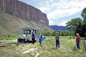
A brisk, windy Saturday morning beckons Bill Zeedyk and a crew of “white collar muscles” to the Wolf Creek basin in Gunnison. It’s October in the high Rockies. The morning weather is turbulent with rain and snow as the shivering volunteers listen to the day’s instructions. Bill is wearing Muck boots, layers of flannel and fleece, jeans, a fishing hat and the thick of his beard to keep him warm. For a man in his sixties, he’s sturdily built, and he’s been plugging away since the wee hours of the morning. In a soft-spoken manner Bill urge us to stay hydrated and watch our footing. The author of the book Let the Water Do the Work, Bill has years of experience in the Forest Service and holds a wealth of knowledge within him; and along with training volunteers in water conservation, he is also busy in the fields of rock masonry and hydrology.
Bill owns Zeedyk Ecological Consulting and works closely with the New Mexico-based Quivera Coalition. The Coalition is a group of experts in the fields of ranching, stream rehabilitation and land management. They have helped restore over 100 million acres of ranchland and 30 miles of linear streams. Specifically, Bill teaches his watershed techniques – a mixture of erosion control using rock and wood structures – to people around the American West, so they can continue restoring damaged streams. Water in Colorado and the West is a scarce resource, and it is absolutely essential to conserve its riparian areas for future use. Today, working on the Gunnison Climate Working Group’s Climate Adaptation project, he teaches us – students and volunteers from the BLM, Western State Colorado University, the Nature Conservancy and the local community – about stream rehabilitation.
Apprehensively, we put on our work gloves and carry, hoist or roll rocks to the mucky channel. We’re all a little afraid of mucking up, but we crack jokes like, “It’s not like it’s rock-et science.” This channel has been undercut by the water, and what was once a wetland area is dried up, becoming less than functional. Bill says, “The stream has been degraded and we want to A-grade it.” These structures are deceptively simple in material – rock and dirt – but sophisticated in planning. The creek bed is sticky with mud and sedges but lacks water. It’s October in the Rockies. At this point the creek beds run dry or contain little but a trickle.
We are working in a basin among hills thick with sagebrush. Sagebrush is Gunnison’s pride, a keystone species for wildlife, and defines our semi-desert mountain landscape at 7,703 feet. Bill first informs me that sagebrush, if saturated in water, will die in 36 hours – compelling. I then inquire, “But how do they stay alive in the winter with all of our snow?” He tells me that the roots in the winter are not saturated in water. There is a lot of aeration at the root level and the snow sits atop the soil. The hills around us support a thriving community of Wyoming sagebrush plants. Here in the lower basin, there are next to none. Only a few immature shrubs make their way down to the basin floor. Their absence is one way we know that water once lived here. Bill points out the presence of other “indicator species” that help us know that this was a wetland. Many plant species have a water threshold; those that like it in the middle are often indicator species. One such species is yarrow. Yarrow thrives only if the soil is moist, and we see yarrow on the basin floor. We also see other hydrophilic (water-loving) species all around us, such as arctic rush, willows and sedges. We see invasive species such as musk thistle and Canadian thistle.
To return the basin to its previous wetland state we need to build a “Media Luna” rock structure. The Media Luna catches the water and spreads it over the landscape. My group makes a tight band of rocks that is three feet wide, at least, and 20 feet long, that tapers downstream. We fill in the rock gaps with dirt or sod, and then we “let the water do the work.” Upstream, another group has been working on another Media Luna, and within the space of two hours the water has already pooled up. The idea behind these structures is to slow down the force of the water. When the water is charging down a steep gradient, it will scour the bed floor, digging an even deeper channel. If you introduce vegetation to these rock structures, the water table will rise as the water slows down.
When we think of the West, we may think of gold strikes, cowboys and Indians, buffalo, great mountains and great tales of wrangling your claim to the land. However there are two major things missing in these pictures: lots of cattle and little water. The 98th Meridian is an invisible line drawn north to south dividing our country into two very different climates, dry and wet. The great western mountain ranges act as a barrier creating a very expansive rain shadow. This effect is what determines the West’s climate. John Wesley Powell, a Civil War veteran, river runner, and surveyor, argued that Jefferson’s 160-acre allotment and grid plan for the West was far from perfect. Powell understood the West; he knew the West was a dry country and that 160 acres would do most families no good without irrigation. According to author Ted Steinberg, Powell proposed “land arrangements of small 80-acre farms and large 2,560-acre livestock ranches, each attached to its respective irrigation and grazing district.” Nothing became of this idea, but it is certain that irrigating the West was the greatest challenge of living there. The second part of Powell’s plan that made perfect sense was the way in which the West would make use of livestock. Ranching takes to the West like ducks to water, so much does one seem to be inseparable from the other. This is because the land in the West is too dry to grow a variety of crops, but it is expansive, and therefore great for big herds of livestock. To this day, this relationship remains the same; Gunnison County is no different.
Many people made a living ranching in the West, and many still do today. Our federal government, in recognition of ranching’s importance to the region, adopted public land use regulations to promote and support it. In the 11-state western region, livestock grazing is permitted on 91 percent of all public lands. Along with public land grazing, there is a substantial amount of private land devoted to ranching and other agriculture: in Gunnison County alone, there are 186 farms and ranches, the average size of which is 900 acres. However, despite ranching’s historical and current significance to the West, improper livestock grazing can have dire consequences for the land. First, improperly managed grazing increases soil erosion and soil compaction, and decreases soil porosity, preventing the recharging of groundwater. Furthermore, grazing heightens removal of native grasses and introduces invasive species. Overgrazing can prevent the establishment of saplings, thus preventing tree and shrub re-vegetation. Improper grazing can also cause trout and other species relocation, and the loss of vegetation near riparian areas increases water temperature, which has innumerable costs.
Gunnison County has a vibrant ranching community, and because we sit at the headwaters of the Colorado, we have a great many mountain streams that help supply irrigation for grazing. Johnson & McCormick, of the National Research Council, inform us that the management of riparian areas “is an important societal concern since riparian zones are among the nation’s most highly valued, yet threatened natural ecosystems.”
The beauty of Bill Zeedyk’s riparian restoration work is that it requires no heavy equipment, steel, concrete or turbines. It allows nature to heal itself with the same natural materials that sustain it. Results happen quickly with these projects, and all that is needed is a little man and woman power and organic matter. It is imperative with our long history of mining, road building, development and livestock grazing that we continue to rebuild these riparian areas if we want to see a future that includes ranching, agriculture and healthy western ecosystems. With better land management, and restoration initiatives like Bill’s, our goal in Gunnison County is to perpetuate the business of ranching without dire consequences to the land and water.
The day is done at Wolf Creek; we’ve successfully re-established a working riparian area and created a large wet meadow for just one mile of stream. There’s a lot more work to be done in the days to come. Luckily, with the enthusiasm and hard work of volunteers, we can reclaim our streams and begin to give back to our homeland.
Michele Parenti is a recent graduate of Western State Colorado University. She has many leather bound books, and crystal stemware, and her apartment smells of rich mahogany.